San Lazzaro bridge - Val Larghe (SAT footpath 472)

Kirándulás

© Consorzio Turistico Piana Rotaliana Königsberg - Dario Sebastiani

© Consorzio Turistico Piana Rotaliana Königsberg - Dario Sebastiani

- Rövid leírás
-
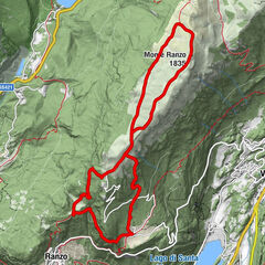
The path goes from the San Lazzaro bridge to the junction with path 420 in the hamlet of Val Larghe near Montevaccino.
- Nehézség
-
közepes
- Értékelés
-
- Útvonal
-
LavisSan Lazzaro di Meano (232 m)0,1 kmNuova Gazzadina1,3 kmVigo Meano2,5 kmLe Gorghe3,9 kmAgli Orti4,3 km
- Legjobb szezon
-
janfebrmárcáprmájjúnjúlaugszeptoktnovdec
- Legmagasabb pont
- 839 m
- Úti cél
-
Boschi Val Larghe woods (intersection 420, 834 m)
- Magassági profil
-
 © outdooractive.com

- Szerző
-
A túra San Lazzaro bridge - Val Larghe (SAT footpath 472) a outdooractive.com feltéve, hogy.
GPS Downloads


Általános információ
Gyógyító éghajlat
További túrák a régiókban