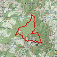
HWW-Hiking route: Zöbern - Mönichkirchen - Hochwechsel

Tanösvény

© Oststeiermark Tourismus - XKarin Hofer

- Rövid leírás
-
This HWW hiking route is part of the Wechselland Historical Long-Distance Hiking Trail (HWW), which tells the story of Wechselland along more than 100 HWW stations. More information can be found at www.wechsel-wandern.at.
- Nehézség
-
közepes
- Értékelés
-
- Útvonal
-
Pfarrkirche St. Georg0,1 kmGasthof Gansterer0,2 kmZöbern0,3 kmKapelle0,3 kmKnolln4,7 kmHartberg (918 m)6,5 kmRasthüttn Brettlbar9,0 kmHeiliger Leopold - Staatsvertag Kapelle9,4 kmMönichkirchen10,0 kmPfarrkirche Mönichkirchen10,1 kmSchauquellfassung11,1 kmBerggasthof Mönichkirchner Schwaig12,4 kmAlpengasthof Enzian12,5 kmHallerhaus13,5 kmStoa Alm14,3 kmSteinerne Stiege (1.505 m)14,7 kmNiederwechsel (1.669 m)17,3 kmWetterkoglerhaus20,4 kmHochwechsel (1.743 m)20,4 km
- Legjobb szezon
-
janfebrmárcáprmájjúnjúlaugszeptoktnovdec
- Legmagasabb pont
- 1.739 m
- Úti cél
-
Hochwechsel
- Magassági profil
-

-

-
SzerzőA túra HWW-Hiking route: Zöbern - Mönichkirchen - Hochwechsel a outdooractive.com feltéve, hogy.
GPS Downloads


Általános információ
Kulturális/Történelmi
További túrák a régiókban
-
Wiener Alpen
3048
-
Wechselland - Wiener Alpen
1704
-
Mönichkirchen
358