
- Rövid leírás
-
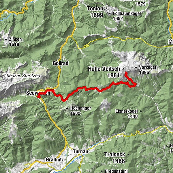
Stage 4 - at a glance:
Start: Seewiesen, the "Styrian Heiligenblut", tourist information, accommodation, cab services: Tel.: +43 664 3548485, www.turnau.gv.at/tourismus cab services: Taxi Steiner Tel.: +43 3862 51333 and Taxi Hochschwab Reisen Tel.: +43 3861 2400
GPS grid N 47° 37' 14,3" E 15° 16' 15,3"Destination / overnight stay: Graf Meran Haus on the Veitsch, Tel.: +43 664 1513 220, http://www.bergsteigen.com/huetten/graf-meran-haus
GPS grid N 47° 38' 41,5" O 15° 24' 33,4"
Alternative: Scheikl mountain inn at the foot of the Veitsch, Tel.: +43 3856 2349
Stage length: 18.6 kilometers
Total walking time (without breaks): 7 ½ hours
Meters in altitude ascent: 1,430 meters in altitude
Meters in altitude descent: 540 meters in altitude
Difficulties: not difficult, but long stage
- Nehézség
-
nehéz
- Értékelés
-
- Útvonal
-
Hotel Restaurant Seeberghof0,1 kmKatholische Pfarrkirche St. Leonhard Seewiesen0,3 kmSeewiesen0,5 kmSeebergalm2,8 kmStrobl-Hütte5,6 kmGöriacher Alm5,6 kmRotsohlalm12,7 kmAlpengasthof Scheikl16,8 kmGraf Meran Haus19,6 km
- Legjobb szezon
-
janfebrmárcáprmájjúnjúlaugszeptoktnovdec
- Legmagasabb pont
- 1.828 m
- Úti cél
-
Graf Meran Haus on the Veitsch
- Magassági profil
-


-

-
SzerzőA túra Etappe 04: BergZeitReise Seewiesen - Veitsch a outdooractive.com feltéve, hogy.


Általános információ
-
Hochsteiermark
4082
-
Pogusch - Steirische Romantik
1536
-
Turnau
394