


- Rövid leírás
-
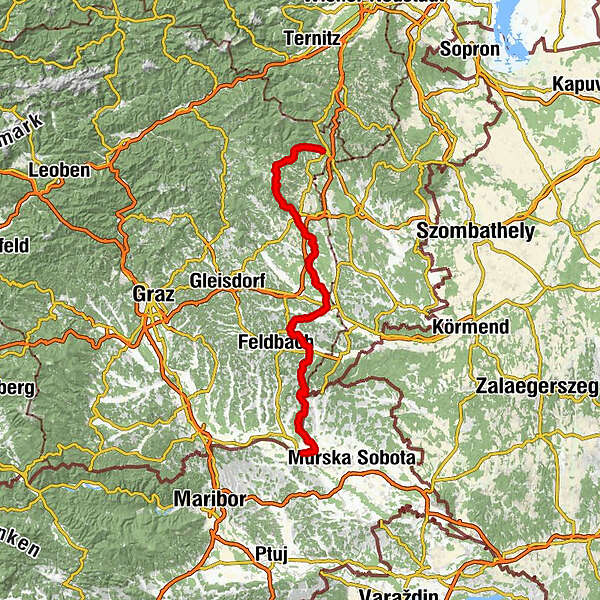
The section of the East-Austrian Border Trail through Styria leads us from Friedberg at the foot of the Wechsel through East Styria and the Spa and Volcano Region to Bad Radkersburg, the romantic border town in the border triangle of Austria - Hungary - Slovenia. Those interested in culture will get their money's worth at Vorau Abbey in Joglland or Riegersburg Castle in Vulkanland, among others, and culinary delights along the entire route - this is the way to do it in Styria.
The long-distance trail with the number 07 has a total length of about 710 km and starts on the Nebelstein in the Waldviertel, even leads through the federal capital Vienna and meets the Southern Alpine Trail 03 in Bad Radkersburg. On our crossing of East Styria, we take the access from Friedberg to Vorau via Trail 07 A, a variant of the main trail.
- Nehézség
-
közepes
- Értékelés
-
- Útvonal
-
Friedberg0,0 kmSchwaighof2,1 kmOrtskapelle Herz Jesu2,1 kmAuerbach8,2 kmHl. Laurentius10,4 kmSankt Lorenzen am Wechsel10,6 kmVorau19,7 kmFilialkirche Marktkirche hl. Ägydius19,8 kmGasthof Pension „Vorauerhof“19,9 kmKutscherwirt Hotel-Restaurant20,1 kmWiesberg32,2 kmSt. Hubertus Kapelle38,7 kmHartberg42,0 kmSchildbach42,4 kmSpielplatz des Gasthofes Pack42,8 kmWallfahrtskirche Maria Lebing42,8 kmGrabner43,9 kmOberbuch47,6 kmGasthaus Falk48,0 kmGrubberg50,9 kmSankt Magdalena am Lemberg51,1 kmSchmiedböck53,1 kmCafé Bar am berner56,8 kmPfarrkirche hl. Margaretha58,6 kmBad Waltersdorf59,0 kmLeitersdorfberg62,9 kmBergstadl63,0 kmLoimeth66,0 kmSpeltenbach72,8 kmLedergasse74,3 kmGrazer Vorstadt75,0 kmFürstenfeld75,2 kmJulerltal78,6 kmSöchau80,1 kmPfarrkirche heiliger Veit80,8 kmTautendorf bei Fürstenfeld82,5 kmLoiberg (392 m)85,5 kmLemberg85,9 kmOberlembach87,7 kmRiegersburg90,5 kmBuschenschank Christiner Hannes96,0 kmStückelberg96,6 kmRattenberg98,6 kmBrunn100,1 kmFehring102,3 kmBurgfeld104,9 kmKuruzzenschenke105,7 kmKuruzzenkogel (425 m)105,7 kmKapfensteinerhof109,5 kmKapfenstein110,0 kmSichauf116,3 kmBuschenschank Hakl117,0 kmSt. Anna am Aigen120,1 kmRutschen120,2 kmPfarrkirche St. Anna120,2 kmGasthaus Strasser120,5 kmDeutsch Haseldorf127,0 kmGasthof Weinlandhof128,0 kmKratzer128,2 kmHochwarth129,1 kmBuschenschank Gießauf-Nell129,4 kmRestaurant Klöcherhof130,4 kmKlöch130,4 kmDer.Platz.Wirt132,1 kmPölten133,5 kmKarlsdorf (222 m)136,0 kmKaltenbrunn138,5 kmZelting139,6 kmLindenhof143,6 kmLaafeld143,9 kmBad Radkersburg145,4 kmFrauenkirche145,5 km
- Legjobb szezon
-
janfebrmárcáprmájjúnjúlaugszeptoktnovdec
- Legmagasabb pont
- 1.223 m
- Úti cél
-
Bad Radkersburg
- Magassági profil
-


-

-
SzerzőA túra East-Austrian Border Trail 07 through Styria a outdooractive.com feltéve, hogy.


Általános információ
-
Thermen- & Vulkanland
1324
-
Bad Blumau
525
-
Großwilfersdorf
146