© Bregenzerwald Tourismus - Ligia Gonzalez

© Bregenzerwald Tourismus - Ligia Gonzalez

© Bregenzerwald Tourismus - Ligia Gonzalez

© Bregenzerwald Tourismus - Ligia Gonzalez

© Bregenzerwald Tourismus - Ligia Gonzalez

© Bregenzerwald Tourismus - Ligia Gonzalez

© Bregenzerwald Tourismus - Ligia Gonzalez

© Bregenzerwald Tourismus - Ligia Gonzalez

© Bregenzerwald Tourismus - Ligia Gonzalez

© Bregenzerwald Tourismus - Ligia Gonzalez

- Rövid leírás
-
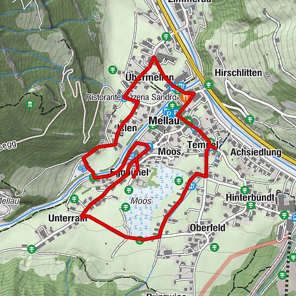
In Mellau, the people live with the Kanisfluh – to the great delight of most of the locals. And to the astonishmentof the guests! The mighty mountain is the home of myths such as the story of the Swedish soldier who got lost and wound up here during the Thirty Years’War. In the part of the village called Übermellen, typical, old Bregenzerwald houses dominate, whereas Oberfeld’s villagescape is determined by contemporary residential buildings. Mellau is the only village in the region not to have its cemetery next to the church.
- Útvonal
-
Pfarrkirche Mellau0,0 kmMellau0,0 kmRistorante Pizzeria Sandro0,2 kmÜbermellen0,5 kmIslen0,7 kmMoos1,5 kmEggbühel1,8 kmUnterrain2,0 kmOberfeld2,6 kmTempel2,9 kmAchsiedlung2,9 kmNaze's Hus3,0 kmPlatz3,2 km
- Legjobb szezon
-
janfebrmárcáprmájjúnjúlaugszeptoktnovdec
- Legmagasabb pont
- 714 m
- Úti cél
-
Church square Mellau (village hall, tourist information)
- Magassági profil
-


- Szerző
-
A túra Umgang Mellau a outdooractive.com feltéve, hogy.
GPS Downloads


Általános információ
Ígéretes
További túrák a régiókban
-
St. Gallen - Bodensee
2067
-
Biosphärenpark Großes Walsertal
2011
-
Mellau
639