


Urwaldpfad Leutenberg - Thuringian Urwaldpfade


The Thuringian Urwaldpfad runs through the most beautiful forests of Leutenberg.
Many lovely resting places and viewpoints invite you to linger along this nature-close path.
It is recommended to hike counterclockwise....
The Thuringian Urwaldpfad runs through the most beautiful forests of Leutenberg.
Many lovely resting places and viewpoints invite you to linger along this nature-close path.
It is recommended to hike counterclockwise. The path is not barrier-free and not suitable for bike routes.
The hiking distance is 6.8 km. However, three steep climbs require stamina.
Leutenberg train station – Unterhütte – Goldkuppe - Cronebrunnen junction - Wandslebhütte - Cronebrunnen junction – Cronebrunnen – Eichendorffplatz – Save Nature Group - Gustav-Fehler-Hütte – Kalkgrubental – Schleifberg - Naturpark-Haus Leutenberg – Mühlgraben - Leutenberg market square – Leutenberg train station

Start the hike at the stele in front of the parking lot at Leutenberg train station.
After crossing the tracks of the Sormitztalbahn railway, walk parallel to them through Rosenthaler Straße (K161).
After about 500 m, turn left onto K162 towards Rosenthal. This little-used road passes a pond located on the grounds of the Flight Center for Paragliders and Motorized Paragliders.
www.flugzentrum.com
Shortly before the green town entrance sign of Unterhütte, a path leads uphill into the forest and up to the Goldkuppe.
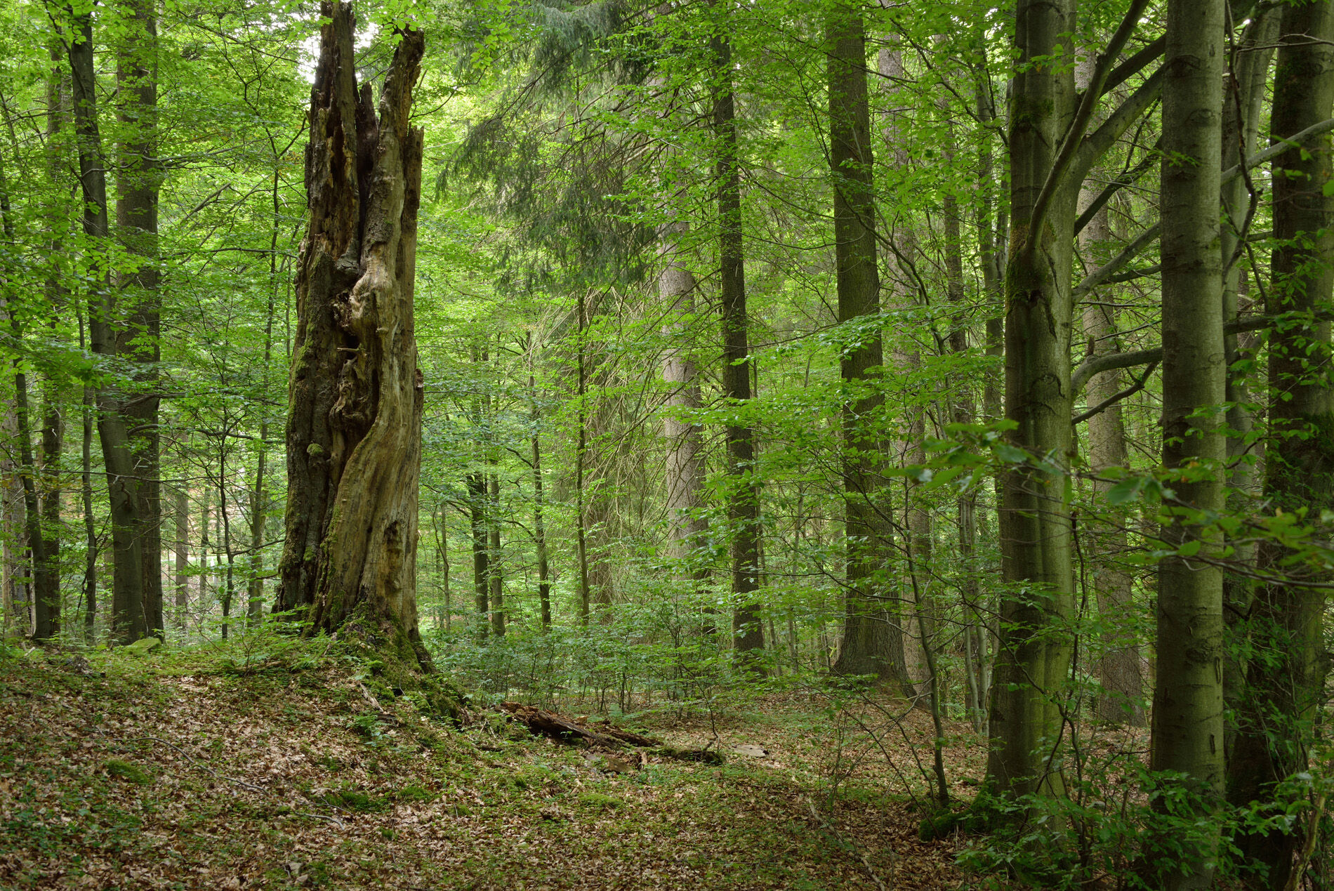
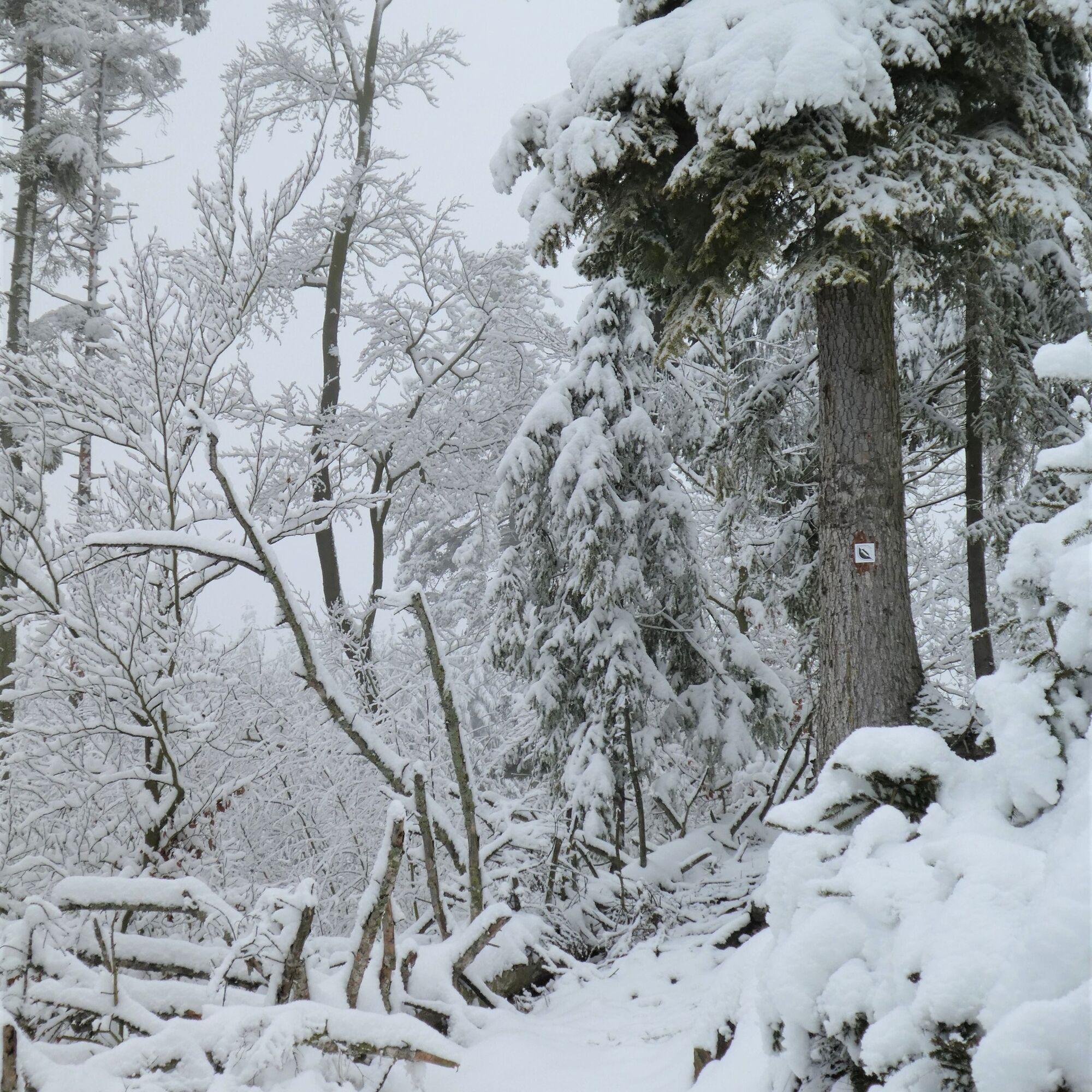
Here you will be impressed by a multitude of deadwood trees lining the path.
The path passes an old slate mine tunnel, which must not be entered.
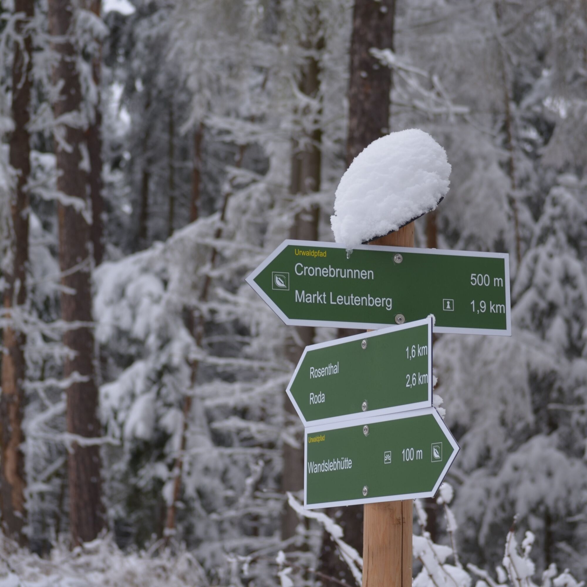
After the city comes into view for the first time, a hiking trail sign points left down to the Cronebrunnen, which would shorten the hike. However, you keep slightly right so as not to miss the Wandslebhütte 400 m away. This ascent also requires stamina.
You continue uphill via a path and steps. At the end of the stairs, keep left to enter a wider grassy path. After 250 m, the path turns sharply right and after a short descent, steeply uphill to the already visible Wandslebhütte. On this short 400-meter section, you climb about 50 meters in elevation.
The effort is definitely worth it.
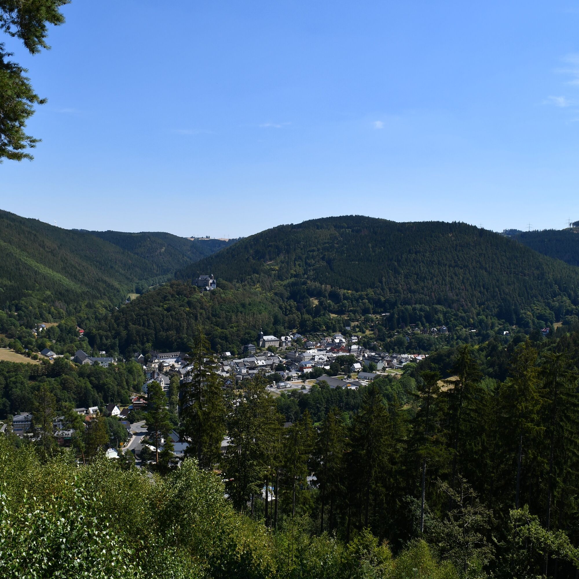
As a reward, there is a cozy spot to rest with a great view over Leutenberg and the surrounding ridges to the northwest.
The view extends over Löhmberg and the Lemnitztal to the district of Munschwitz/St. Jakob. Next to it rises the Tannberg. East of the Ilmtal, the Friedensburg castle towers on Schlossberg, to which Kirchberg is connected.
The following descent requires surefootedness. You use a zigzag path that leads back onto the grassy path you came on and hike back to the Cronebrunnen junction.
The next descent also requires surefootedness.
Robert Crone distinguished himself as mayor in the development of his hometown.
The landscape around the Cronebrunnen is characterized by an impressive primeval forest-like stand of old silver firs, sycamore maples, spruces, and beeches. These are relics of an original “Herzynian mixed mountain forest”.
From the Cronebrunnen the path leads to Eichendorffplatz, where it is also pleasant to linger.
The text of “Der frohe Wandersmann” (The Happy Hiker), one of the most popular German hiking songs, was created in 1823 by the poet Joseph Karl Benedikt Freiherr von Eichendorff.
“Whom God wants to bestow true favor,
He sends them into the wide world;
To them he will show his wonders
In mountain and valley and river and field.
The lazy ones lying at home,
Are not refreshed by the morning glow;
They only know about cradles,
And worries, burdens, and need for bread.
The little streams jump from the mountains,
The larks soar high with joy,
Why shouldn’t I sing with them
With full throat and fresh chest?
I just let dear God rule,
The little streams, larks, forest, and field
And earth and heaven will sustain
Even if my affairs are in the best order!”
The path to Gustav-Fehler-Höhe leads over the grounds of the Save Nature Group.
The non-profit conservation organization Save Nature Group is a network of volunteers who live and act in harmony with nature.
Founded only in 2017, the organization has earned recognition for creating orchards, revitalizing the Ilmbach stream, and organizing litter collection campaigns.
Save Nature Group also operates the Rodaberghütte with nature helpers from all over the world. A beautiful nature educational trail leads to a newly established orchard. On the orchard, a protected resting place with a walkable green roof and wonderful view has been created.
www.save-nature-group.de
Upon reaching the Gustav-Fehler-Höhe, the eponymous hut invites you to rest.
Here you can not only enjoy a break but also a view over the “city of seven valleys” towards Friedensburg Castle.
The Gustav-Fehler-Hütte was built in 1884 by the Leutenberg beautification club in honor of Prince Georg Albert of Schwarzburg-Rudolstädter as Georgs Höhe.
In 1945 it received its current name. Gustav Fehler was commander of the Leutenberg volunteer fire brigade from 1920 to 1932. Together with Ernst Pabst, he ensured that his fire brigade became one of the best in the then Thuringia region.
Immediately behind the Gustav-Fehler-Hütte begins the steep descent down a path into the urban area of Leutenberg. This descent also requires surefootedness. In the Kalkgrubental several paths intersect.
There is a shortcut option here: if you go straight across the railway tracks, you will reach the market square after 400 m. However, this means missing a beautiful natural section of the Urwaldpfad as well as the Naturpark-Haus.
A detour to the children’s farm, 300 m away, is also worthwhile from here.
Founded in August 2009, the Leutenberg Children’s Farm in the Green association aims to make rural life tangible again in Leutenberg. This includes working more with animals, not just for children. Another goal is to bring city people closer to nature again. Everyone interested in animals and nature is welcome here.
The facility is open to everyone who wants to help.
www.leutenberger-kinderbauernhof.de
According to the hiking trail sign, a staircase leads up, which shortly after changes to a path. This requires stamina once again. After about 300 m, you reach the site of the former Kaiser-Friedrich-Tower.
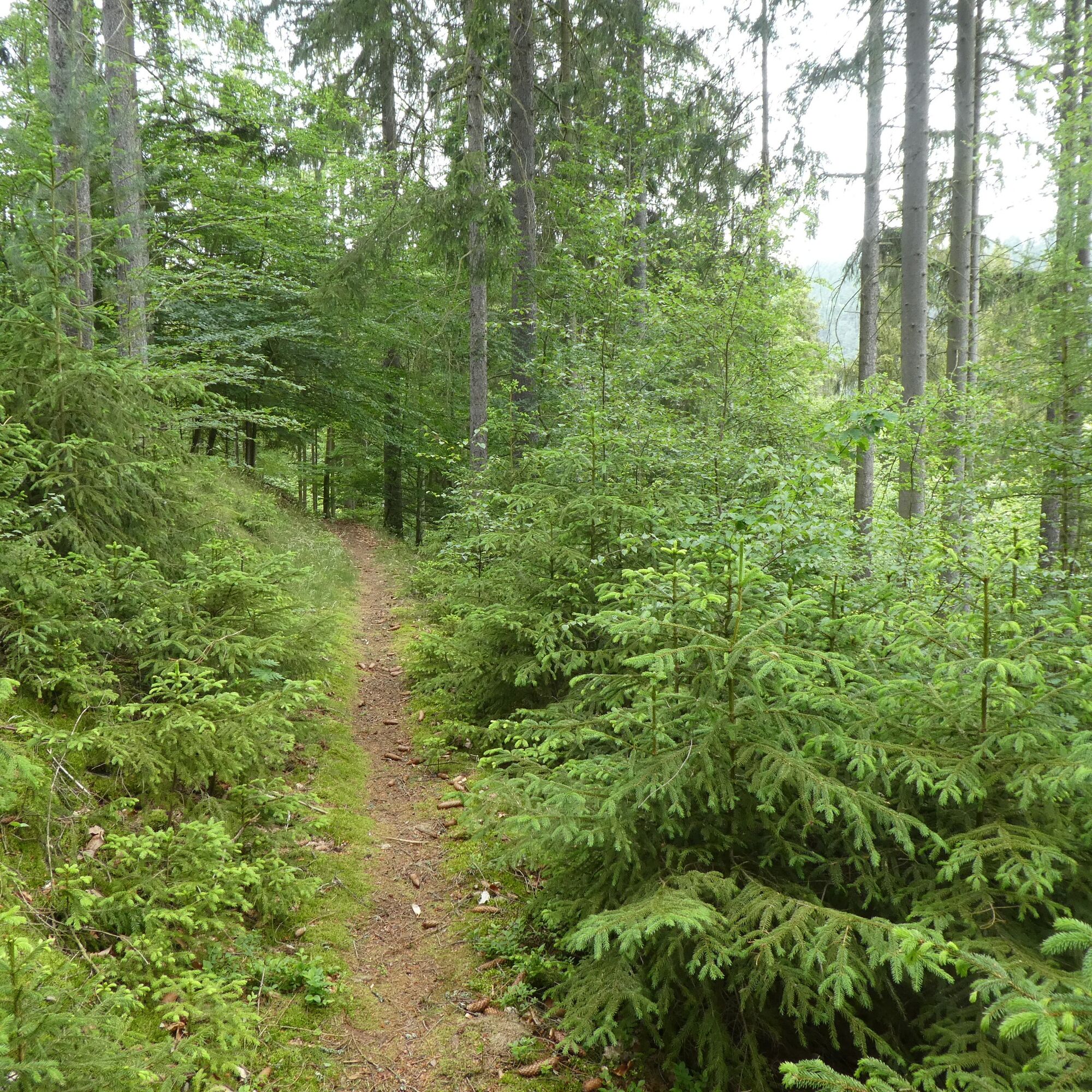
The wild romantic path now leads along the Schleifberg.
The structure of the forest shows that the axe has long rested here, and a primeval forest path is gradually developing.
On the well-marked trail, you pass several junctions with hiking signs. Though several shortcuts to the market are offered, you should always orient yourself towards the Naturpark-Haus Leutenberg. That way, you won’t miss anything on this fantastic trail.
Following this, you walk to the junction 400 m away. A hiking sign points to the Naturpark-Haus, 1.2 km away. The Urwaldpfad snakes left downhill into the valley.
If you keep right, after about 1 km you reach the “Seven Valleys Viewpoint”, another attractive hiking destination around Leutenberg.
Before the railway tracks, turn sharply right and walk parallel to them. On the right, you pass the Garkochteich pond. Shortly after, you reach the grounds of the Naturpark-Haus Leutenberg.
The Naturpark-Haus not only houses the administration of the Thuringian Slate Mountains/Upper Saale Nature Park. Nature lovers will find exhibitions on the nature park with a terrarium and an extensive collection of sparkling minerals. The comprehensive geopark exhibition “Adventure Earth History” lets visitors dive far into the past.
Outside the facility, artistically designed NatureParkWorlds lead you through a varied stream landscape along the Sormitz path. Two playgrounds delight the youngest visitors in particular. Interactive elements playfully convey contact with nature.
The nature park covers an area of 830 square kilometers. It serves as an important link between the surrounding landscapes of the Frankenwald Nature Park in the south and the Thuringian Forest Nature Park in the west. Besides the Rennsteig trail, the European long-distance path E3 (EB) and the “Green Belt” along the former inner-German border connect both regions. The National Geopark “Slate Land” now also belongs to this network.
www.thueringer-schiefergebirge-obere-saale.de
From the Naturpark-Haus, you are accompanied by the Leutenberg children’s hiking trail “On the Trail of the Fire Salamander” to the market square of Leutenberg. Then you cross the Sormitz bridge to Wurzbacher Straße (B90), where you turn right.
Right next to the parking lot of the Naturpark-Haus is another stele of the Urwaldpfad Leutenberg, from where the hike can also be started.
Now cross the busy road and follow a sidewalk heading into town. After 100 meters, you leave the federal road and follow a signpost towards the market square. Along the former Mühlgraben, you finally reach the center of the small town Leutenberg with its market square.
There, follow the main street, then turn left into the street called “Am Ilmbach”. You pass a roundabout again on B90, cross the Sormitz bridge again, and return to the starting point at Leutenberg train station.
Sturdy footwear
Sufficient water
Provisions
Don't forget: sturdy footwear and sufficient water
Opposite the train station is also the parking lot for the Urwaldpfad Leutenberg.
The B90 crosses through Leutenberg leading to the A9 near Bad Lobenstein. In the opposite direction towards the A71, the B90 is interrupted in the neighboring village Hockeroda, from where you can get to Rudolstadt via the B85. Afterward, the B90 leads again to the A71 near Stadtilm.
Leutenberg is located on the EB 32 railway line from Saalfeld to Blankenstein/Saale, the place where the Rennsteig simultaneously begins or ends. Train connections with suitable bus transfers can be explored via the Deutsche Bahn travel portal (reiseauskunft.bahn.de).
Leutenberg train station
Other parking options: parking lot at the Naturpark-Haus on Wurzbacher Straße and at the market square in Leutenberg
Further parking options: Leutenberg market square and the parking lot at the Naturpark-Haus at 16 Wurzbacher Straße.
Here is another entry portal to the Thuringian Urwaldpfad Leutenberg, which offers an alternative starting option.
You want not only to experience nature but also to protect it? Here you can find all information about the autumn fundraising hike "Hiking for Biodiversity"
Népszerű túrák a környéken
-
5,0
Circular route around the "Slate Lake" - Lehesten - Thuringian Forest
könnyűKirándulás 3,01 km -
4,7
Circular hiking route - H3 "The Bird's Eye View" - Thuringian Forest
közepesKirándulás 8,76 km -
4,7
Circular hiking trail - H5 "The Water Route" - Thuringian Forest
közepesKirándulás 6,58 km -
4,0
Circular route - "Wichtelweg" - Wilhelmsdorf
könnyűTanösvény 2 km -
Circular route - Otter Bay and Devil's Pulpit - Ziegenrück
közepesKirándulás 16,8 km -
Children's path in Leutenberg "On the trail of the fire salamander"
közepesKirándulás 5,36 km -
5,0
Hohenwarte Reservoir Way - Section 2 - Camping Wilhelmsdorf Portenschmiede → Ziegenrück
közepesKirándulás 18,3 km -
Circular hiking trail - Slate Trail on the "Green Belt" - Probstzella - Thuringian Forest
közepesKirándulás 56,7 km -
MTB Saalfeld 13: Hohenwarte Reservoir Circular Route
közepesMountainbike 46,4 km -
Hiking - Hohenwarte Reservoir Trail - Thuringian Forest
közepesKirándulás 78,0 km
Túrázás & nyomkövetés


Ne maradjon le az ajánlatokról és az inspirációról a következő nyaralásához!
Az Ön e-mail címe hozzá lett adva a levelezőlistához.