


Sauerland-Höhenflug: From Altena to Neuenrade-Wilhelmshöhe


The route starts at Altena Castle, one of the probably most beautiful hill castles in Germany. For some years now, a (paid) experience elevator has connected Altena city center directly with the castle....
The route starts at Altena Castle, one of the probably most beautiful hill castles in Germany. For some years now, a (paid) experience elevator has connected Altena city center directly with the castle. You shouldn’t miss this lift at the start of the route. The actual hiking route then starts at the castle gate and leads first down into Nettetal. From here you hike steadily uphill to the panorama panel at Hegenscheid. Then it continues towards Quitmann Tower, which stands on top of the Kohlberg - with a wonderful 360° view. Your next destination is the source of the Hönne, which from here heads towards the Ruhr. Shortly after, you reach Neuenrade. The stage ends in the Wilhelmshöhe area at the B 229.

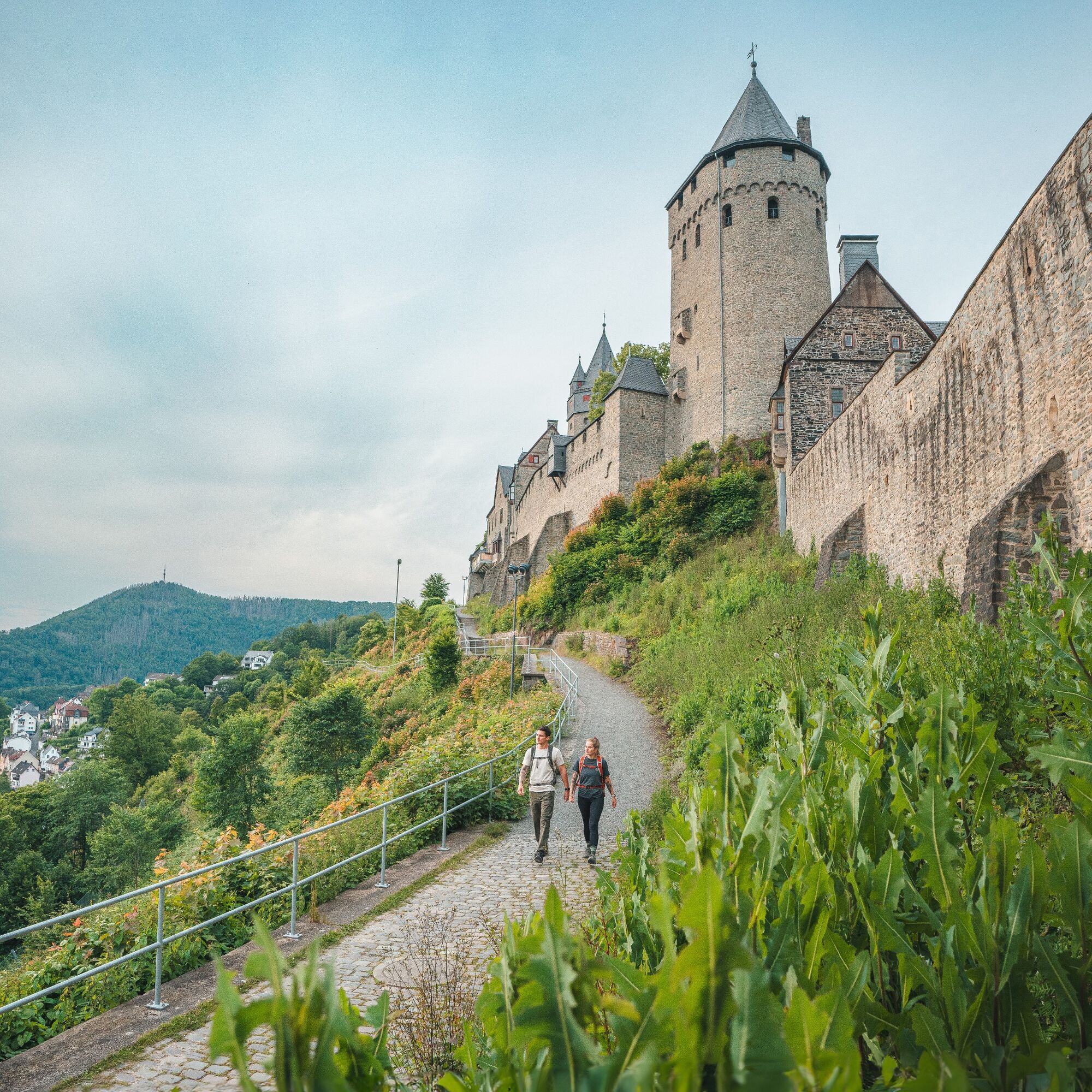
In the middle of the Lenne Valley lies the old wire-drawing town of Altena. High above the town towers Altena Castle, one of the most beautiful hill castles in Germany, which originated about 900 years ago. At that time, the brothers Adolf and Everhard built the castle on the spur of the Klusenberg. In 1912, Richard Schirrmann established the first youth hostel in the castle. This first world youth hostel, like Altena Castle itself, can be visited.
Right at Altena Castle at the entry portals in front of the mighty castle walls begins the Sauerland-Höhenflug. The path first leads down through narrow alleys into a side valley (please do not miss the stair descent between the houses above the road crossing of the L 698) before the hiking trail rises again on the opposite mountainside. You might get sweaty during the ascent to Altena - Hegenscheid! A seating area therefore invites you to take a break halfway. The hiking section runs parallel to the wire trade trail, which runs from Lüdenscheid to Iserlohn and provides information on the history of iron extraction and wire production via panels. Along the way, you will pass the ridge "Toter Mann", which got its name from the exhaustion of the iron deposits there at the beginning of the 17th century. The ascent is rewarded on the 473 m high Hegenscheid with a fantastic view! The Höhenflug now continues to Neuenrade without any strenuous ascents.
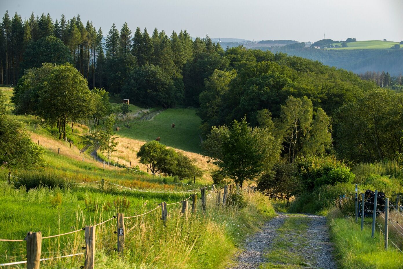
On the Hegenscheid is the airfield of the Luftsportverein Hegenscheid, where, in good weather, motor planes up to 2 tons start for a round flight. The Höhenflug runs parallel to the airfield, repeatedly with wonderful views, then over the Rüssenberg (434 m) to the villages of Ihmert and Elfenfohren, whose history dates back to 1813. On both the Rüssenberg and the ridge "Auf dem Giebel" above Dahle, the Kyrill storm created many open spaces, which, in addition to distant views, also reveal a wonderful bloom of St John's wort, willowherb, and foxglove especially in the summer months.
The Höhenflug now runs through the Neuenrade city forest. Besides the Neuenrade Baby Forest, where families can plant a tree for the birth of their child, there is also the "Tree of the Year" avenue here, consisting of the Trees of the Year since 1989.
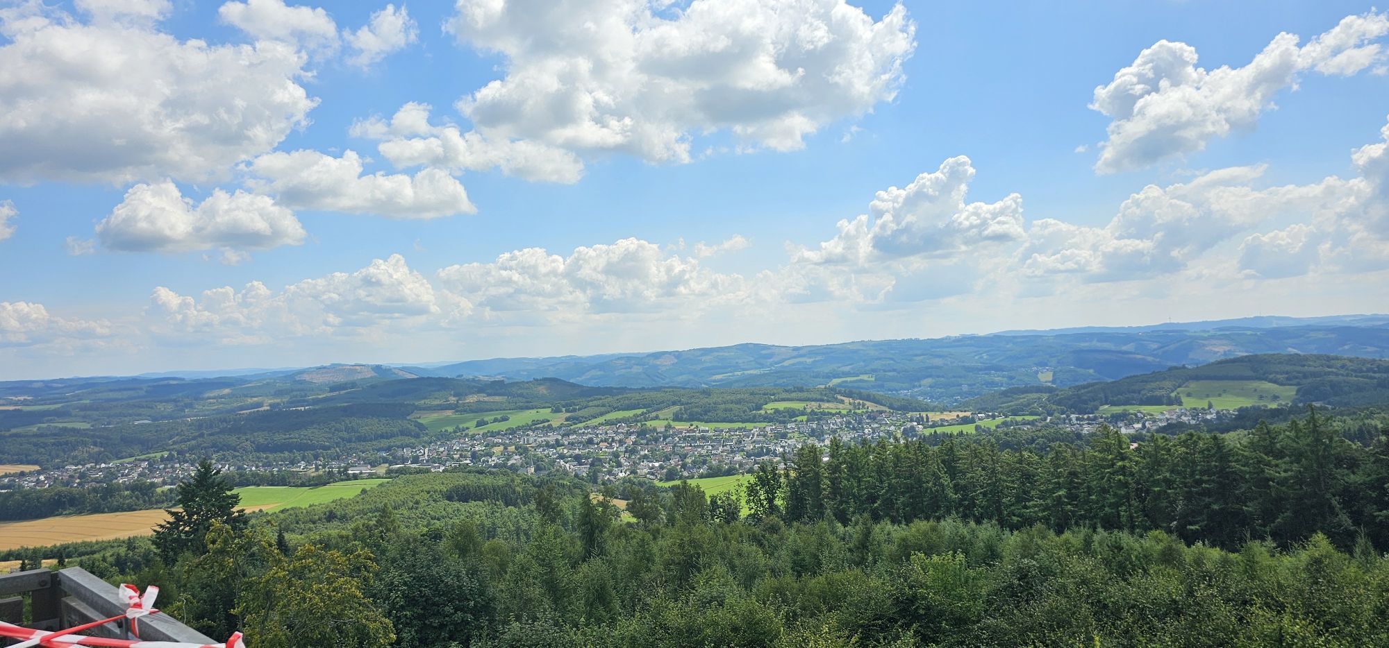
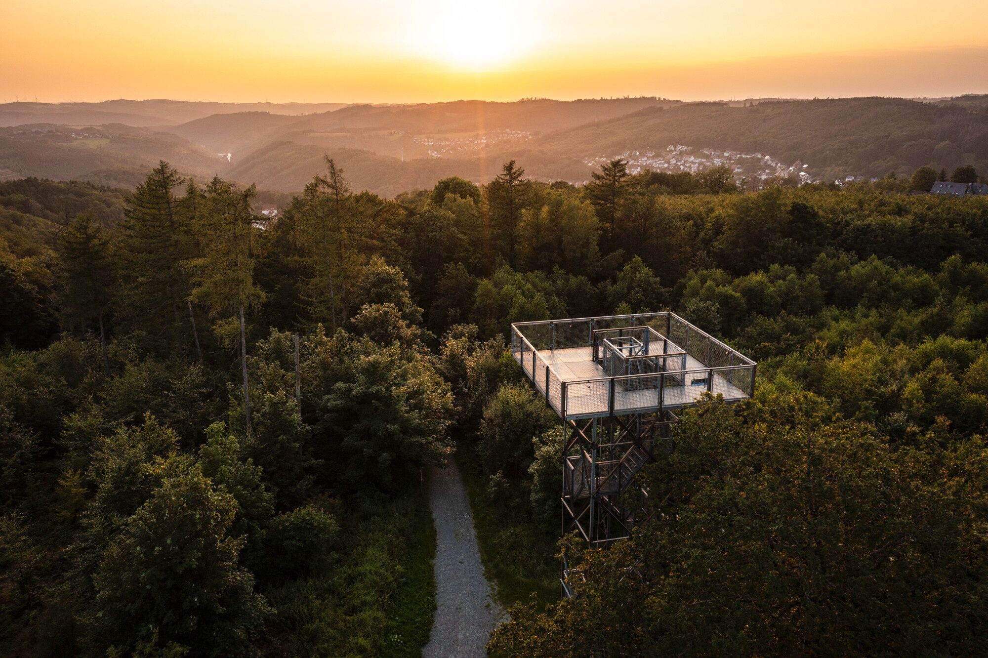
Passing the SGV memorial, the Höhenflug now reaches the Kohlberg (514 m), the highest elevation of the city of Neuenrade. The 14 m high Quitmann Tower on the summit was rebuilt by the city of Neuenrade in 1986. The first observation tower at this spot dated back to 1892 but was destroyed by a storm in 1986. Small panorama panels on the Quitmann Tower explain the landmarks of the magnificent 360° view.
Passing the "Kohlberg" parking lot, the hiking trail now crosses the L 698. At the large Attig, after the Kyrill storm in January 2007, only a single beech group remains, and hikers are offered a beautiful and almost limitless view into the valley. A bit further is a panorama panel that informs the hiker about important viewpoints.
The Hönne springs at the south slope. It flows through Balve and Menden. The Hönne Valley is an impressive valley with rocks, cliffs, and caves in one of Germany's most important karst areas. A large copper stele at the source illustrates the course of the Hönne to the hiker.
Through winding paths, partly along the Hönne, you now reach Neuenrade. Our stage on the Sauerland-Höhenflug ends in the Wilhelmshöhe area at the B 229. Here is a bus stop from where you can get back to Altena or Neuenrade.
Those who still have stamina can also walk the 4.8-kilometer access path of the Sauerland-Höhenflug from Wilhelmshöhe to Werdohl station and take the train back to Altena there. More information about the access path and the trails marked with a white 'H' on black background can be found here.
You can reach Neuenrade station on foot by following the yellow marking of the Sauerland-Höhenflug about 2 kilometers further to the forest experience trail. Via the 1.5-kilometer-long access path described here from the forest experience trail, you reach Neuenrade station.
No special equipment required
Altena: From the A45 motorway (Sauerland line), take the Lüdenscheid-Nord exit and then follow the signs to Altena. From the A46, take exit Iserlohn-Oestrich and then follow the signs to Altena.
Neuenrade: Leave the A45 at junction 14 - Lüdenscheid - and drive right towards Werdohl. Follow the B229 for about 15 km to the entrance of Neuenrade. Coming from the A46, leave the motorway at junction 46 - Arnsberg-Hüsten - and follow the B229 for about 30 km to Neuenrade.
In Altena/Starting point Altena Castle: Travel to the city of Altena is possible all day by train with the RE16, which runs between Siegen and Essen. The entry to the hiking trail is via an access path in the city center towards Altena Castle (information panels at the station). From the central bus station, buses run from Werdohl (Bus 36), Iserlohn (Bus 37), Hemer (Bus 33), and Lüdenscheid (Bus 37). A transfer between the station and the castle path, the stop at the Sauerland-Höhenflug entry, is also possible using various city buses. From there it is only a few meters north to the beginning of the Sauerland-Höhenflug!
Exact timetable information at http://www.bahn.de and http://www.mvg-online.de/.
Those who want to travel back to Altena from the destination Wilhelmshöhe can use the 4.8-kilometer-long access path from Wilhelmshöhe to Werdohl station and take the train back to Altena from there.
In Neuenrade/ Starting point Wilhelmshöhe: The Wilhelmshöhe stop is served by buses from Neuenrade station (Bus 60, Bus 260, Bus 274), Küntrop (Bus 60, Bus 260), Werdohl (Bus 260), and Altena (Bus 260). It is located directly on the B 229, which is crossed by the Sauerland-Höhenflug just a few meters south (towards the Altenaer Straße/Werdohler Straße intersection).
Neuenrade station can be reached from Unna (RB54), Werdohl (Bus 60), and Küntrop (Bus 60). Two access paths to the Sauerland-Höhenflug start directly at the station. Whether you start on the hiking trail north of the town before the viewpoint "Große Assig" or only south at Gersberg is up to you.
You can also reach the starting point of the Wilhelmshöhe stage from Werdohl station by following the access path marked with a white 'H' on a black background from Werdohl station. Travel to Werdohl station is possible all day with the RE16, which runs between Siegen and Essen. From the destination of the stage in Altena, you can conveniently take the train (RE16) back to Werdohl.
In Neuenrade: Wilhelmshöhe parking lot on L 656 from Werdohl to Neuenrade. Google Maps coordinates: 51.275068,7.770257
In Altena: "Langer Kamp" parking lot on the Lenne riverbank. From here a black-marked access path leads to Altena Castle. Google Maps coordinates: 51.292569,7.672238
Igen
Service hotline of the Sauerland-Höhenflug: 02974 - 202 199
Népszerű túrák a környéken
-
3,5
The Fickeltünnes Trail - Hiking on the history hiking trail around Allendorf
közepesTanösvény 14,3 km -
Circular hiking trail in Langscheid "Schlösser route"
közepesKirándulás 14,2 km -
4,0
Rundweg an der Versetahlsperre
közepesKirándulás 10,9 km -
Plettenberg: History Route XL
közepesBiciklizés 40,3 km -
Ice cream and café route Plettenberg-Herscheid with Oestertalsperre
közepesBiciklizés 31,8 km -
Plettenberg: History Route XS
könnyűBiciklizés 9,07 km -
Sonntagslauf Iserlohn-Brandkopf-Danzturm-Forsthaus Löhnen-Kesbern-Dahlsen-Zur Mühle-Hegenscheid-Lössel
könnyűKirándulás 18,2 km -
Steltenberg Letmathe
könnyűKirándulás 3,48 km -
Waldluft & Lenneblick
közepesKirándulás 14,7 km -
3,0
Schalksmühle circular hiking trail (Δ) - Over the Hülscheider Heights to the babbling Hilmecke
közepesKirándulás 6,35 km

Túrázás & nyomkövetés


Ne maradjon le az ajánlatokról és az inspirációról a következő nyaralásához!
Az Ön e-mail címe hozzá lett adva a levelezőlistához.