


Sauerland-Höhenflug: From Wenholthausen to Bad Fredeburg


This stage begins in Wenholthausen and captivates with fantastic panoramic views, extensive meadows, and beautiful beech and mixed forests. Don't miss the giant bench shortly before Reiste. Here there...
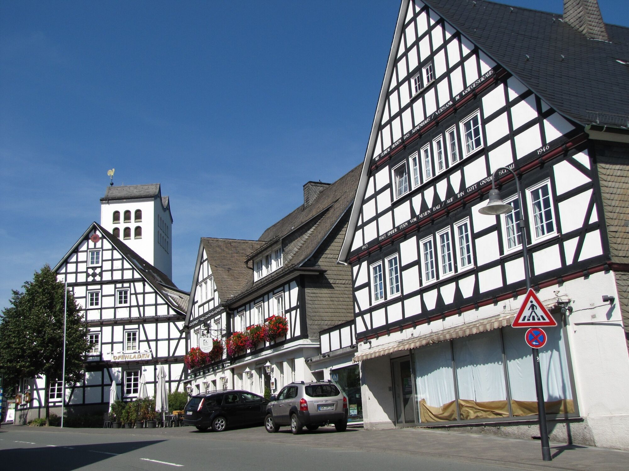
This stage begins in Wenholthausen and captivates with fantastic panoramic views, extensive meadows, and beautiful beech and mixed forests. Don't miss the giant bench shortly before Reiste. Here there are good opportunities for a photo spot. The stage ends in the spa town of Bad Fredeburg, which lies picturesquely at the foot of the Hunau with its historic town center and numerous slate-covered half-timbered houses.
ATTENTION: Long-term trail closure above Bad Fredeburg
Due to construction work, the regular trail section from "Altes Forsthaus" is no longer passable. A detour is set up. For your own safety, please observe this closure. Thank you very much for your understanding.


The stage begins in Wenholthausen at Südstraße / corner "Unter den Dornen". On Südstraße there is also a bus stop. Near Südstraße, a black-marked path meets the main trail, which leads along the Wenne to the church and then to the hiking parking lot in the town center.
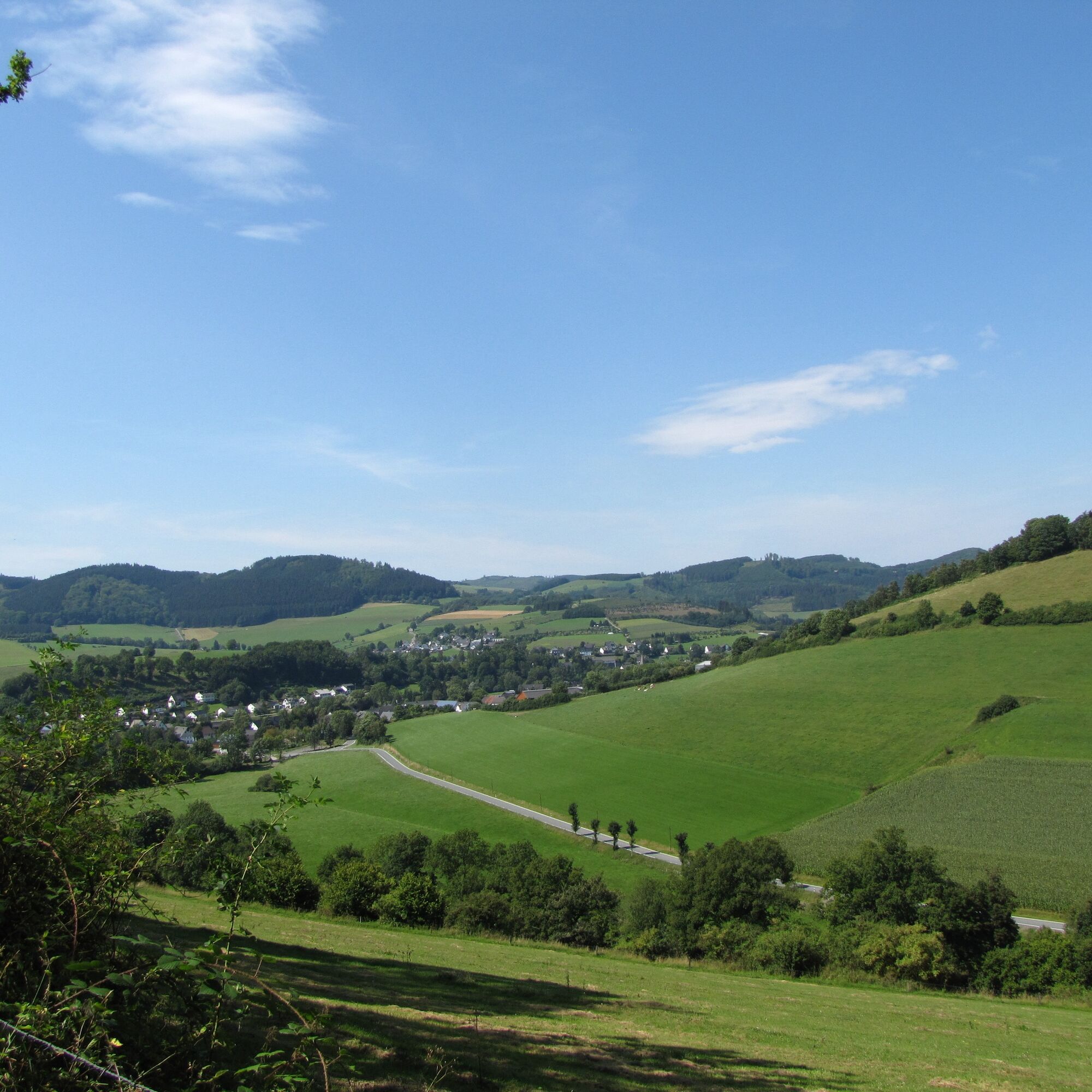
The Sauerland-Höhenflug runs briefly through the idyllic village, crosses the K 41 at the town exit, and then climbs high up to the Gesenberg. At the beginning of the ascent, there is a magnificent view into the meadow valley designated as a nature reserve along the Büemker Bach. The ascent is worth it, as you are rewarded on the Gesenberg with a fantastic view far beyond Wenholthausen. Two panorama boards clearly explain the landmarks to be seen, and a forest bench invites you to take a short break. From the Gesenberg, the hiking trail leads over meadows to above the small village of Büemke, circles around it, and leads with beautiful views into the valley and up to the Reisterberg, whose summit offers a wonderful panoramic view. Here too, you will find a panorama board and a bench at the summit cross invites you to take another rest before the Sauerland-Höhenflug steeply descends through a beech forest toward Reiste. Don't miss the giant bench; it is perfect for a photo spot. In Reiste, the hiking trail passes the hiking portal at the Landgasthof Reinert and crosses the B 55 directly at the parish church of St. Pankratius. The listed church was consecrated to Saint Pankratius in 1852 and houses an organ that partially dates from 1633. Worth a detour is the beehive chapel at the foot of the Reisterberg just outside the village. The chapel was built in 1840 on the Lohhof and served to produce beeswax for church purposes. Beekeeping has since been discontinued.
After Reiste, the Sauerland-Höhenflug leads steadily uphill but always with beautiful views into the Wenne valley and the Reister basin. Along the Hülsenberg, magnificent panoramas open up over the Wenne valley deep into the Homerthi.
With views of Kirchilpe, south of the village where a medieval rampart castle stood whose remains were uncovered in 2000 during excavations, the hiking trail crosses the road leading to Reiste and follows into the valley of the Kleine Ilpe. Varied, through mixed forest and along the forest edge, the path reaches the small settlement of Hengssiepen where two access paths from Oberhenneborn and Sellinghausen meet the Höhenflug.
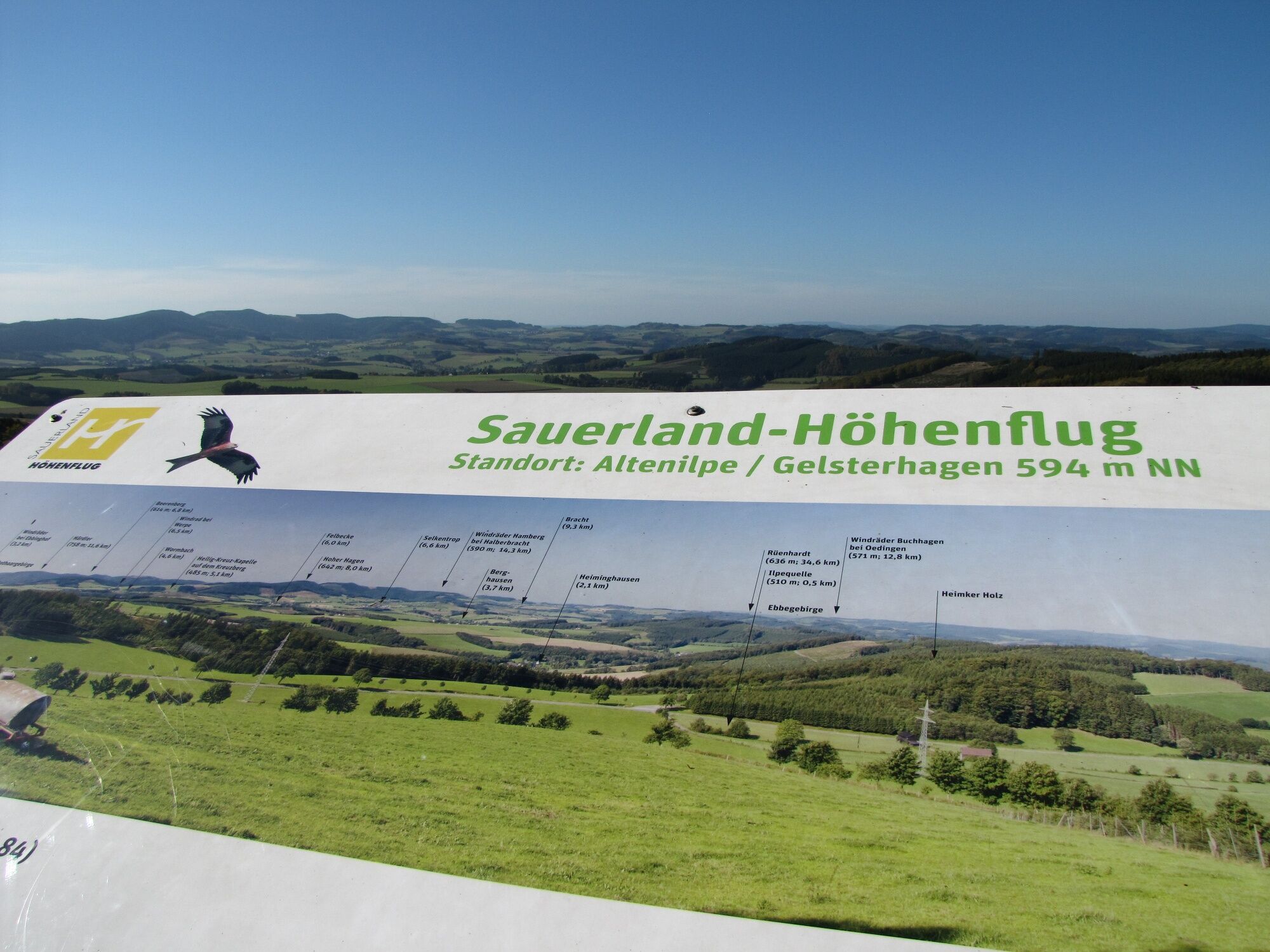
Now the Sauerland-Höhenflug runs along the Somberg over a panoramic trail with fantastic distant views over meadows, forests, mountains, and the village of Altenilpe. Here a break at a picnic table is recommended. Also, after circling Gelsterhagen, the hiking trail meets a magnificent panoramic viewpoint above the Ilpe spring. A 2-meter-high panorama board explains the view over the Rothaar Mountains and the Ebbe Mountains. In clear weather, the view extends to the Nordhelle, 35 km away.
Over a path, the Sauerland-Höhenflug reaches the forest inn "Altes Forsthaus," located deep in the spruce forest.
ATTENTION: Long-term trail closure above Bad Fredeburg. Due to construction work, the regular trail section from "Altes Forsthaus" to Bad Fredeburg is no longer passable. A detour to Bad Fredeburg is set up. We hope for your understanding.
[In a magnificent beech forest, you will encounter the marksman's cross towering above Bad Fredeburg. While one access path leads straight ahead to Rimberg, the Sauerland-Höhenflug turns right and follows a steep hollow path down to the forest educational trail and the small chapel at Buchhagen. From there, it continues down a stations of the cross path to Bad Fredeburg.]
This picturesque spa town at the foot of the Hunau lies in one of the most forest-rich regions of Germany. Worth seeing are the many slate-covered half-timbered houses in the town center and the court museum, which exhibits props from centuries of judicial history. The stage ends at the main road L 776. From the Sparkasse bus stop, there is a bus connection back to Wenholthausen.
No special equipment required
Wenholthausen: From Meschede via B55 towards Eslohe, turn right at Hennesee. Via the villages of Enkhausen and Schüren you reach Wenholthausen. Coming from Eslohe, you first drive via B55 and then continue via L 541.
Bad Fredeburg: From Meschede via B 55 to Bremke. Turn left here and follow B 511 to Bad Fredeburg. From Schmallenberg via B 236 to Gleidorf and then continue via B 511.
In Wenholthausen: The stops Wenholthausen, Beckmann, and Wenholthausen, Hotel zur Post are connected towards Bad Fredeburg, Eslohe, and Freienohl (line 367). From the stop, the Sauerland-Höhenflug is only a few meters from the main street. At the intersection of Südstraße (main street) and Unter den Dornen street, you will encounter the Höhenflug trail.
In Bad Fredeburg: Bad Fredeburg can be reached from Meschede (S90), Schmallenberg (S90), Eslohe (369), Freienohl (367), and Oberhenneborn (465). The Sauerland-Höhenflug runs through the town and crosses the main street at the church. The Sparkasse bus stop is located just a few meters below the church.
More information at http://www.rlg-online.de.
The Schmallenberger Wanderbus also serves both stage towns! Details at http://www.schmallenberger-sauerland.de/freizeit-region/service/kostenloses-busfahren/
In Wenholthausen: Hiking parking lot at Südstraße in the town center, from here a black-marked access path leads along the Wenne to the Sauerland-Höhenflug; Google Maps coordinates: 51.289091, 8.175833
In Bad Fredeburg: At Schützenplatz, Kurhaus or at the school center.
Sauerland-Höhenflug service and booking hotline: 02974 - 202 199
Food and accommodation options:
Landhotel und Wandergasthof Sauerländer-Hof
Südstr. 35
59889 Eslohe-Wenholthausen
Phone: 02973 – 97960
Email: info@sauerlaender-hof.com
www.sauerlaender-hof.com
Hotel Kleins Wiese
Kleins Wiese 1
57392 Schmallenberg - Bad Fredeburg
Phone 02974 - 96960
info@kleins-wiese.de
www.kleins-wiese.de
Landgasthof Seemer
Südstraße 4
59889 Eslohe-Wenholthausen
Phone 02973 - 570
Email: info@seemer.de
www.seemer.de
Népszerű túrák a környéken
-
4,5
Hike to the waterfall
közepesKirándulás 15,8 km -
4,0
Mining trail in Ramsbeck
közepesTanösvény 9,94 km -
4,3
Short round around Hennesee
közepesBiciklizés 14,3 km -
Bestwiger Panoramaweg (B)
közepeshosszú távú sétaútvonal 56,2 km -
5,0
SinnePfad at Hennesee
közepesTanösvény 2,83 km -
Mescheder Höhenwanderweg (M)
közepesKirándulás 65,7 km -
Circular route Linnepe
közepesKirándulás 8,36 km -
Ramsbeck circular route (R2)
közepesKirándulás 10,0 km -
5,0
Chapel circular route Calle (C)
közepesKirándulás 13,5 km -
Small Henne circular route (M2)
közepesKirándulás 13,2 km
Túrázás & nyomkövetés


Ne maradjon le az ajánlatokról és az inspirációról a következő nyaralásához!
Az Ön e-mail címe hozzá lett adva a levelezőlistához.